


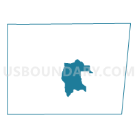
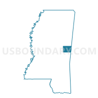
Band Building Voting District, Kemper County, Mississippi
About
Outline

Summary
| Unique Area Identifier | 605880 |
| Name | Band Building Voting District |
| County | Kemper County |
| State | Mississippi |
| Area (square miles) | 41.81 |
| Land Area (square miles) | 41.78 |
| Water Area (square miles) | 0.03 |
| % of Land Area | 99.93 |
| % of Water Area | 0.07 |
| Latitude of the Internal Point | 32.71206360 |
| Longtitude of the Internal Point | -88.60916030 |
Maps

Graphs
Select a template below for downloading or customizing gragh for Band Building Voting District, Kemper County, Mississippi


Neighbors
Neighoring Voting District (by Name) Neighboring Voting District on the Map
- City Hall And Fire Dpt. Voting District, Kemper County, MS
- Courthouse Voting District, Kemper County, MS
- Farmers Market Voting District, Kemper County, MS
- Kemper Springs Voting District, Kemper County, MS
- Mt. Nebo Fire Station Voting District, Kemper County, MS
- Porterville Voting District, Kemper County, MS
Top 10 Neighboring County Subdivision (by Population) Neighboring County Subdivision on the Map
- District 5, Kemper County, MS (2,339)
- District 2, Kemper County, MS (2,010)
- District 1, Kemper County, MS (1,781)